Underground Surveys in Stocksbridge
Enquire Today For A Free No Obligation Quote
At Underground Surveys, we provide specialist underground mapping services for residential, commercial, and industrial properties in Stocksbridge and across the UK.
Our surveys locate and identify subsurface utilities, such as drainage systems, without the need for excavation, supporting architects, developers, and engineers with reliable, actionable data.
Whether you’re preparing for development, managing existing infrastructure, or resolving unknown utility routes, our underground surveys offer accurate results using advanced, non-invasive technology.
Why Are Underground Surveys Essential for Properties in or Around Stocksbridge?
In Stocksbridge, underground surveys are a crucial step in any project where detailed knowledge of subsurface features is required for planning, safety, or compliance.
These surveys are particularly important prior to excavation, construction, or major refurbishment, helping avoid damage to unknown services and reducing the risk of costly project delays.
Which Types of Properties Across Stocksbridge Require Underground Surveying?
We carry out underground surveys in Stocksbridge across a wide range of property types, including:
- Development sites and construction zones – For safe planning and layout design.
- Residential housing schemes and new builds – To verify utility connections and drainage layouts.
- Educational institutions and campuses – For ongoing maintenance and infrastructure improvements.
- Offices and commercial facilities – Assisting change-of-use projects and building upgrades.
- Factories and industrial sites – Mapping complex underground networks for safety and expansion.
- Renovation or redevelopment projects – Establishing existing subsurface infrastructure before starting works.
How Much Do Underground Surveys Cost in the Stocksbridge Area?
The cost of underground surveys in Stocksbridge ranges from £400 to over £1,200, depending on the site size, complexity, and reporting requirements.
Prices are influenced by the number of access points, utility types involved, whether GPS-referenced plans or CAD outputs are needed, and optional add-ons like condition reporting or CCTV footage.
Contact Underground Surveys in South Yorkshire to request a tailored quote for your site.
Can You Map Subsurface Drainage Systems Without Excavating in Stocksbridge?
All our underground surveys in Stocksbridge are completed using non-intrusive methods such as CCTV inspection, electromagnetic tracing, and GPS surveying.
This allows us to map underground routes and features without digging. We work through existing access points such as manholes, rodding eyes, and inspection chambers to track pipe routes, depths, and connections.
Do Underground Surveys in Stocksbridge Include Sewer, Surface, and Foul Drain Identification?
Our underground surveys in Stocksbridge accurately identify foul, surface, and combined drainage systems, ensuring compliance with planning and environmental requirements.
We also document additional infrastructure such as soakaways, interceptors, chambers, and outfalls, offering a full picture of your site’s below-ground services.
How Long Does an Underground Survey Take for Sites in Stocksbridge?
For most residential sites in Stocksbridge, underground surveys can be completed within a few hours. Larger or more complex commercial premises may require 1 to 2 days.
We typically deliver comprehensive reports, including annotated plans and survey data, within 2 to 3 working days after the site visit.
Are Underground Survey Reports in Stocksbridge Suitable for Planning and Building Control Use?
Our underground survey reports in Stocksbridge are formatted for use with building control submissions, planning applications, and coordination with utility providers.
Each report includes clear utility layouts, invert levels, pipe sizes, flow directions, and material types. GIS and CAD file formats are available to support integration into architectural or civil engineering workflows.
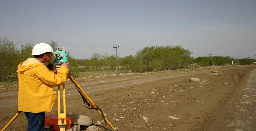
What Technology Is Used for Underground Surveys in Stocksbridge?
We use advanced, industry-standard tools to deliver high-quality underground survey data in Stocksbridge, including:
- CCTV camera systems – For inspecting internal pipe condition and alignment.
- Electromagnetic locators – To trace utility paths from surface level without excavation.
- Sonde tracers – Inserted into pipework to determine exact layout, direction, and depth.
- GPS surveying units – Used to position subsurface features on detailed maps.
- CAD software – For preparing accurate utility drawings and planning documents.
How Do Surveyors in Stocksbridge Ensure Accuracy in Obstructed or Confined Systems?
For underground surveys in Stocksbridge, we use high-definition crawler and push-rod cameras to access tight or complex networks.
Where access is restricted, we conduct multiple entry point tracing to complete full-route documentation. In confined or hazardous areas, our team uses tripod entry systems and gas monitors and complies with confined space safety protocols.
Contact Underground Surveys to schedule a consultation or request a site visit in Stocksbridge.
Find More Info
Make sure you contact us today for a number of great underground surveys services in Stocksbridge.
For more information on underground surveys in Stocksbridge S36 1, fill in the contact form below to receive a free quote today.
★★★★★
“The underground survey team was professional and thorough. We now have a clear picture of what lies beneath our site, which saved us time and money.”
Graham Webster
South Yorkshire
★★★★★
“Accurate results and a friendly approach. The survey identified hidden services we didn’t know about, preventing costly mistakes during construction.”
Louise Cartwright
South Yorkshire